A Circular Walk Around the Teifi Pools

We haven’t posted a walk for a while, not because we haven’t done any walking  but because of a general lack of inertia when it comes to posting the details.

The Cambrian Mountains are a wild and empty plateau lying between the Snowdonia and Brecon Beacons National Parks. They are Wales’ fourth national park in-waiting; designated in 1972, the Park was later cheated of recognition and protection, by an unholy alliance of landowners and politicians. It remains surprisingly unknown to a lot of people.

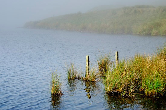
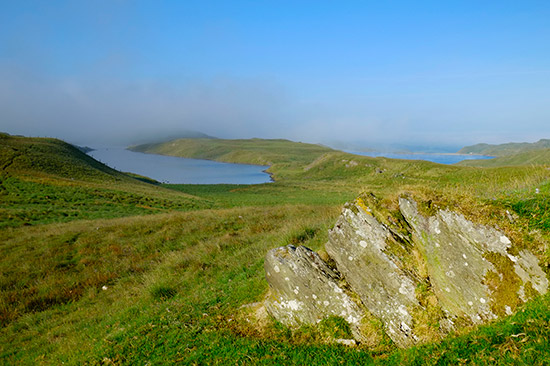
The Teifi pools lie to the north east of Strata Florida and are a group of lakes situated about 1500 ft up the western slopes of the Cambrian Mountains and this is a rather exceptional walk on a fine day. It can get very wet underfoot so good boots (and gaiters?) are essential pretty much any time of year.

Teifi Pools Map
Teifi Pools Map

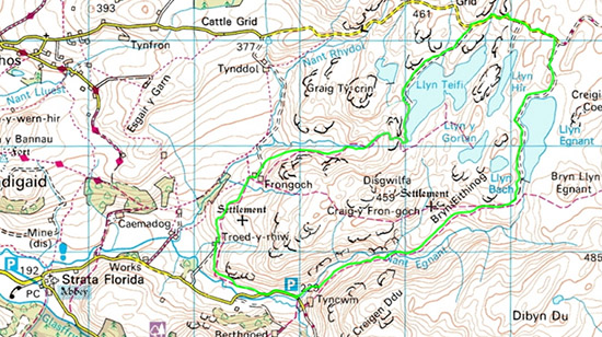
As we are in the middle of an unusual heatwave in July 2013 we set off in the campervan the night before to make an early start. The walk is approached from a ‘no through’ road from Strata Florida and there is parking for about 3 or 4 cars at the point marked on the map above. There was no one else there at around 10.00 pm other than a lot of midges! So we camped there before setting off about 5.30 in the morning. The walk starts about 100 metres BEFORE or west of the parking place not where the footpath is shown in the map  If you try and take this route you’ll be going straight through a farm (Tyncwm) full of barking dogs. The path is an easy uphill, past a cairn, until you reach Llyn Egnant. Here the track becomes tarmac as it is a service road for the reservoir. Keep going until you reach a ‘T junction’ then turn left.

Llyn Egnant in the mist
Llyn Egnant in the mist early on a summer morning

Continue along this track with Llyn Hir on your left until you come to a board indicating that you have reached Llyn Teifi. Turn left and follow this track, through a gate until you reach the dam. Go through the small double metal gates then follow the track under the dam. Follow the lake side across all the other small dams. Once you have gone across the last one turn back sharp right and find the fairly indistinct track down the valley. Keep going down until you reach a small cairn, just ahead is a waymarked fence. Follow the path along the fence. The path turns away (left) by a marker post and goes up to another small cairn. The track should be more distinct now.

The Teifi Pools as the mist clears

Follow the track towards the farm Frongoch. Go through the gate and in front of the house turn right and go over the ladder stile in front of the farm buildings. Keep following the track all the way to Troed-y-rhiw. When you come to the white holiday cottage there is a gate on the left, go through it into the field and follow the path across the field to a stile. Go over the sile and follow the contouring path down to the road. Turn left on the road and walk back to your starting point.

The walk is about 6.5 miles in total.


Share

A Walk in the Preseli Hills from Mynachlog-ddu

Monday the 16th January 2012 turned out to be quite a pleasant sunny day so having made some sandwiches and packed the camera we set of to Mynachlog-ddu, which means Black Monastery in Welsh, to explore some of the Preseli Hills.

Walk in the Preseli Hills
A Walk in the Preseli Hills Starting and Finishing at Mynachlog-ddu

This is wonderful countryside and an area rich with ancient monuments and mysterious places; not to mention being the source of the stone for the inner circle at Stonehenge.

We parked in the car park just where you enter the village and then walked north up the road for a few hundred yards before turning left along the road then after a little while took a right turn which crosses a cattle grid onto the common.

The Bluestones Monument on Mynachlog-ddu Common. Two stones were helicoptered down from the Bluestones outcrop of Carn Menyn (visible in the background of the image) in 1989. The other stone was taken to Stonehenge.

Follow the road across the common, passing the Bluestones Monument, and up to where the bridleway leaves the road (it is also possible to park here if you want to drive to this point). Leave the road and head gently uphill going virtually due north. The gradient is gentle with spectacular views. The path can get boggy in places and needs a little careful negotiation. Eventually, near the ridge,  the path meets another path crossing at ninety degrees. Take a right turn (East) and continue up towards the large stones/cairn, Carn Bica (shown below).

Cairn
Carn Bica

From here you walk down to Bedd Arthur (Arthur’s Grave) a small stone circle. This so-called stone circle lies overlooking the Bluestones outcrop of Carn Meini. It is actually oval or horse-shoe shaped leading to speculation that it may have been this site which influenced the original horseshoe of Bluestones at Stonehenge.

It comprises thirteen small standing stones along with two or three more now fallen. Some believe it may be a henge – others claim it is the remains of a small portal dolmen.

Bedd Arthur
Bedd Arthur or Arthur's Grave a Stone Circle in the Preseli Hills.

From Bedd Arthur continue in an Easterly direction along the track eventually you will pass behind a large conifer plantation, that looks very alien in this wild landscape, before descending back down to the road.

At this point note the memorial stone and take a moment to remember that what is now taken for granted (access to the Preseli Mountains and their prehistoric remains) was once nearly denied to the public. The plaque reads:

These mountains would not be accessible to walkers today if it were not for the brave stand by local inhabitants at the end of the 1940s. Soon after the Second World war, in November 1946, the War Office declared its intention to turn the Preselau into a permanent military training area.
That would mean turning more than 200 farmers from their homes. However, under the leadership of Nonconformist ministers and local headmasters, a spirited campaign was organised to withstand the threat. A barrister was employed to represent the Prescelly Preservation Committee and it was made abundantly clear that not an inch of land would be surrendered.
 
‘We nurture souls in these areas,’ was the precise comment of the Rev R. Parri Roberts when confronted by military officers. The ‘sanctity’ of the mountains was emphasized with their 38 bluestones transported to Stonehenge, over two thousand years ago, to become part of English heritage.
By spring 1948 the Government had give in to the determination of the people of Preselau. All present day farmers and walkers are indebted to those heros of yesterday. The full story can be read in the book ‘Battle of the Presaelau – the campaign to safeguard the ‘sacred’ Pembrokeshire Hills’ by Hefin Wyn.
Once back on the road turn south-west and walk back to your starting point at Mynachlog-ddu. The complete walk is around 7.5 miles. Enjoy!
Share

The Elan Valley

The elan valley
Mist in The Elan Valley

Oh dear we’ve been very lax in updating the blog recently. Too busy enjoying ourselves. For the last two weekends we’ve been spending time in the Elan Valley camping overnight in a wood near Rhayader in mid Wales and photographing and walking round the lakes during the day. We were there to take advantage of the amazing Autumn colours and as you can see from the photographs this was enhanced by the amazingly still water.

The Amazing Autumn Colours at Carreg-ddu

The dams, reservoirs and 73 mile of aqueduct of the Elan Valley waterworks in mid Wales were mostly built about a hundred years ago to supply clean water to the city of Birmingham in the English Midlands. Although it looks like a bridge the Carreg-ddu dam (below) is partially submerged to keep the water level up at the extraction point.

Carreg-ddu Submerged Dam

Leaving aside the morality of removing the original residents to flood the valley the reservoirs and dams which supply water to Birmingham entirely by gravity are a an amazing feat of engineering. It is almost beyond comprehension that thousands of men could build these structures. It really does put in perspective the rubbish that we see built today. In addition the foresight of elders of Birmingham to conceive and undertake such a scheme is astonishing. As well as building the dams this also involved building a 73 mile long aqueduct down which the water travels at less than 2 miles per hour, taking one and a half days to get to Birmingham.

The Foel tower is where water starts its journey to Birmingham

There is more information on the Elan valley dams here.

The walk around Carreg-Ddu reservoir is a lovely walk and you can start at various points. We parked at the car park by the Carreg-Ddu dam and did a complete circuit of the lake. The map below shows a longer walk starting at the visitor centre.

Carreg-ddu Walk
Carreg-ddu Walk
Share

Snowdon and ‘Huey’

Well summer is drawing to an end and it’s time to introduce you to our new friend ‘Huey’ as he (it) is known. Having had a Landrover since we came to Wales (which was indispensable in the worst of the winter) we had to acknowledge that we didn’t use it enough the rest of the year and what we really wanted was a campervan. This led to a big dilemma as we didn’t want to be running three vehicles. Eventually we ‘bit the bullet’ and decided to buy a VW California 4motion. One of the few vans that comes in a 4×4 configuration. So after handing over an inordinate amount of money here is ‘Huey’.

'Huey' named after his numberplate

So after an initial weekend away walking in the Radnor Forest last weekend we seized a brief interlude in the weather and drove up to Snowdon last night to climb Snowdon or Yr Wyddfa as it is known in Welsh. We over-nighted in a small lay-by not far from Beddgelert and then drove to the car park at Rhyd Ddu (off the A4085 – SH 571 526) to have breakfast and make an early start.

Room with a View
Our Room with a View Complete with Quilt Cover from the Charity Shop

The plan was to walk up Snowdon via the Rhydd Ddu path and descend via the Snowdon South ridge. Other than a slight navigational error on the descent that is what we did. The walk up took us around two and a half hours. The cloud cover cleared, as forecast, as we ascended giving us some good views at the top. The routes up Snowdon are detailed here our route is below.

Rhydd Ddu Track
Rhydd Ddu Track and Snowdon South Ridge Walk

The ascent up Rhyd Ddu is fairly gentle in most places, the South Ridge path is a tad more challenging.

Near the Start of the Ascent from Rhydd Ddu
The Ascent up Snowdon
The South Ridge of Snowdon
The South Ridge of Snowdon. In the distance is where the Routes Diverge.
Near the Summit of Snowdon
Near the Summit of Snowdon and quite possibly the highest sheep in Wales!
Liz Near the Summit
Liz Near the Summit with the new Cafe in the background where most Tourists Arrive by Train

All in all we had a great couple of days and we’re pleased to have ‘Huey’ to help us to take advantage of the amazing countryside in Wales

Share

Circular Walk from Bedd Morris to Aberfforest and Return

Another lovely sunny day, so we set off for the glorious Pembrokeshire coast for another of our walks. Although it is now the height of the holiday season here in Wales and there are more people on the beaches few people seem to venture far from the tourist spots. So it is quite possible to have this glorious countryside mostly to yourself.

This walk starts at the Bedd Morris standing stone at SN 038 365

To get there turn left off the main Newport to Dinas road (A487) immediately after leaving Newport. The road is signed Fford Bedd Morris.

Rocky Out Crop Near Bedd Morris

Bedd Morris has had an eventful history since its Bronze Age origin; incorporated in the boundary of the parish of Newport, it also formed a route node for the medieval Newport-Haverfordwest highway, or ‘Ffordd Bedd Morris’, which still crosses Mynydd Carningli. In later years it is said that the name is said to derive from the bandit Morus who once lived among the rocks and robbed travellers. It is etched with a surveying benchmark and other inscriptions.

Circular Walk from Bedd Morris to Aberfforest and Return

Park at the car park by the standing stone then walk slightly back down the road before turning left off the road at the wooden finger post towards a large outcrop of rocks (photo above). From here you can follow a well worn path that descends down toward the coast. This eventually turns into a farm track before reaching the A487. Cross the main road and proceed down a concrete track (slightly to your right after crossing the road) and go through a farm yard. Eventually, near some cottages, you will see a sign pointing you to the coastal path. Take this and turn right following the coastal path with amazing views (see photo below) until you come to Aber Rhigian.

The Amazing Pembrokeshire Coast
The Amazing Pembrokeshire Coast - as good as it gets.

When you come to a small wooden bridge leave the coastal path and follow the path inland back up a shady path. You will eventually reach another vehicular track that will bring you back to the main road. Turn left on the A487 and after fifty yards or so turn right up a small road/track towards Holm House. Follow the footpath (slightly boggy and indistinct in places) to Y Garn. Here you join and turn right onto the tarmac road for a little way before turning right at the first junction up a road that has a sign showing it is a no through road. After several hundred yards this road degenerates into a track you turn left up a footpath that brings you back onto the road to the car park where you started.

The walk is about 6 miles and will take a reasonable walker about 3 hours. We spent longer stopping for lunch and to watch the birds on the coastal cliffs.  The gradient back to the car park is not steep despite the fact that you walk from sea level to nearly 300m.

Share

Walk from Garn Fawr to Strumblehead

Our friend Paul was renting a small cottage in Trefin on the Pembrokeshire coast this week with the intention of  doing some walks and taking some photographs for a story he was hoping to do, so we decided to go and help him. Paul used to work together with John  doing wedding photography. Paul continues the business, now that John has retired, at www.wessexweddings.co.uk

We met Paul and his dog Ben at the cottage in Trefin and started the walk at Garn Fawr a short drive away. Garn Fawr is an Iron Age hillfort situated on a craggy outcrop of the west end of the Pen-caer ridge. It is a short walk up to the summit of this craggy outcrop from which there are superb views over the bay to Strumble Head and Pwllderi. From there it is a rocky steepish descent down to the coastal path. Paul had to be careful because Ben always had to be in the lead and was upset when he wasn’t. We soon passed a brick building, one of an aligned pair, which were used for carrying out tests on  low level air to surface vessel radar. The other building, located at Strumble Head is now used as a bird observatory. Apparently there are also the remains of a two man coast watchers hut from the first world war.

The walk towards Strumble Head was very pleasant weaving in and out of little hillocks and a mixture of gorse and heather. From the cliff edges we could see Choughs doing their aerobatic display and hear seals on the rocky islets. We even saw House Martins which must have just arrived from their long journey from Africa. There are several rocky  inlets and small bays along this route one in particular, Porth Maenmelyn caught our attention. This is a small wild cove with steps cut into the cliff face apparently cut, about a hundred years ago, by an engineer working on the construction of Fishguard harbour and wanted his own private access to this cove.

Strumble Head
Circular walk at Strumble Head

To  open this walk in Google Earth click here.

After passing the light house at Strumble Head we continued further along the coast path until we reached a white holiday cottage owned by the National Trust where we turned inland. We followed bridleways which, considering how drive the weather had been, were quite muddy because they had been churned up by the horses. Probably this is not a walk we would do in the winter. We passed the smaller iron age fort of Garn Fechan on the way back to the car park at Garn Fawr.

lighthouse at Strumble Head
The Lighthouse at Strumble Head

After finishing the walk we drove back to Traeth Llyfn where John took some sunset photographs on the beach. As dusk fell on a perfect day we walked back to the Sloop Inn in Porthgain for something to eat before driving home.

Sunset
Sunset at Traeth Llyfn © John Burton
Share

Circular Walk to Barafundle Bay Near Stackpole

Barafundle
Circular Walk Barafundle Bay

To open this walk in Google Earth click here.

We decided to explore more of the coast so drove down to the Stackpole estate owned by the National Trust on the Pembrokeshire coast, between the villages of Stackpole and Bosherton. We started our walk at Stackpole quay, a delightful little bay now used by fishermen and pleasure boats. There you can find tea rooms and toilets. We then walked along the coastal path to Barafundle bay. This walk takes you along high cliffs which are a haven for seabirds and occasionally choughs can also be seen here.

danger sign
Perhaps a tad dramatic!

Barafundle Bay has the reputation of being one of the best beaches in the UK. To be honest we thought it pleasant enough but not fantastic – but then we are not ‘beach people’. It is accessed from the path by some steepish steps and is  certainly very sheltered and has beautiful sands.

Barafundle
Barafundle Bay

The exit from the beach is up some more steps through a lovely wooded area.

Trees
Trees at Barafundle Bay (John's photography goes 'arty farty')

The walk continued along the cliff edge to Broadhaven beach where we turned inland to Bosherton Lakes, also known as the Lily Ponds locally. To reach these lakes we walked across the Stackpole Warren Dunes. These lakes were created by the Earls of Cawdor between 1780 and 1860. The lakes occupy 3 narrow valleys which were carved out by glacial meltwater in the carboniferous limestone of the area. They are important for the wildlife found there which includes otters, bats, birds and many wild flowers. It is also an important Stonewort area. Stoneworts are a type of green algae occurring in freshwater and may become calcified. Many British Stonewort species are under threat due to water pollution as they are very sensitive to nitrates and phosphates.

Spring Flowers
Spring Flowers by the Lily Ponds

It is a beautiful area to walk around the lakes passing through many wooded areas.  The walk back to the car park was across farmland and we went past the site of a standing stone but were unable to see it as it was hidden by a wood.

Back at the car park we had tea coffee and cake in the tea rooms (pretty rock and roll huh?) before heading home.

Share

A Walk From Porthgain to Abereiddi on The Pembrokeshire Coast Path

Porthgain walk
Circular Walk from Porthgain

Yesterday was one of the nicest days we have had for a while so we decided to go for a walk choosing a coastal walk because of the possibility of mist in the mountains.

To open this walk in Google Earth click here

This walk is slightly further north on the coastal path than the previous one and is about 45 miles from our house. Porthgain is a pretty village that was once a granite quarrying area and industrial harbour in the early 1900s. At the beginning of the walk we walked past the brick hoppers on the south side of the harbour and climbed some steep steps at the side of white building to reach the coastal path. The brick hoppers were used to store crushed granite before it was shipped. There are many ruined quarry buildings to explore at the start of the walk.

beach
Another view of Traeth Llyfn

We then continued along the path with the watch tower at Abereiddi in sight. Along this first section are high dramatic cliffs.

beach
The Beach at Traeth Llyfn

We then came across the tiny beach at Traeth Llyfn which is reached by some steps. This is a stunningly beautiful remote beach with sand and rocks making it ideal for some photographs and a very pleasant lunch stop. There are very strong currents in the sea here and apparently it can also come in very quickly. It is a spectacular spot.

We then continued onto the Blue Lagoon (Ed. looks more green in my photo – John!) where there are very steep cliffs. The Blue Lagoon was formed from an abandoned slate quarry which was filled with seawater through a breach in the outer wall. This area is popular with coasteerers and divers. The beach at Abereiddi is accessed by a winding path. The is a large car park here and just inland  a group of houses built for the quarry workers but abandoned in the early 20th century after a flood. The ones that remain are presumably holiday cottages. There are ruins of old buildings around the Blue Lagoon. The rocks of Abereiddi bay are easily eroded Ordovician slates and apparently there are fossils of graptolites in the rock. We will have to have a look next time we go there.

blue lagoon
The Blue Lagoon

We made our way back to Porthgain by an inland route following the yellow footpath arrows. There is a lovely view of the valley up to Llanrhian which was carved by glacial melt-water during  the last ice age.

The total distance walked was 4.5 miles. We did not time ourselves as we had several stops for taking photographs.

Share

A Walk up Pen y Fan

Pen y Fan is the highest peak in the Southern UK at 886m.This walk was based around the info on the BBC Wales ‘Weatherman Walking‘ series. The walk described there is a slightly longer version of our walk.

To open this walk in Google Earth click here.

Pen y Fan Walk Map
Pen y Fan Map

We started the walk from the car park in Taf Fechan forest walking along the road for a short way and the along a track at the side of the forest. The track then gradually ascends  around Neuadd Reservoir towards Cribyn. After a while you have a choice of  ascending Cribyn or contouring around the side before starting up to the summit of Pen y Fan. The summit is marked with a stone cairn. Unfortunately it was surrounded in mist obscuring the views.

Pen y Fan from Cribyn
Pen y Fan

Then continue south west where again you have the option to go up to Corn Du before continuing in a south easterly direction along the ridge. Eventually after the reservoir there are two steep descents, we chose the second along side the wood. Note that this area can be boggy and the steep descent tricky in icy conditions as we discovered. We then followed the track back to the car parkWe were walking for about 4 hours including stops and covered 8.5 miles. Unfortunately we forgot to take a memory card for the camera so have used a royalty free photo!


Share

A Walk on the Pembrokeshire Coast Porth Clais to St Justinian and Return

This was the first dry pleasant day for a few days so we decided to go for a short circular walk on the Pembrokeshire coast. The drive down took us through St Davids the smallest city in the UK which is quite picturesque.

Porth Clais Harbour
Porth Clais Harbour
Porth Clais to St Justinians Walk

To see this walk in google Earth click here.The walk started at Porth Clais, which is a small rocky inlet, from  which small fishing boats sail. You can park in the National Trust car park, but be aware that you have to pay during the season. Walk down from the car park to the harbour then take the right hand track up past some old lime kilns. From there we walked along the coastal path towards St Justinian. The track is very well marked  and this section is quite easy with only a couple of short steep ascents. Throughout the walk there are fabulous views of several rocky inlets and quite a wild sea as we had previously had very rough weather.There were several small rocky islands providing good nesting sites for birds and just before St Justinian there is a good view of Ramsey Island which is a RSPB  reserve. See www.ramseyisland.co.uk for more information.We left the coast at Justinian and took a short walk along the lanes, which at this time of year are very quiet, back to the car. It is possible to avoid most of the road by walking across the National Trust land but there are some very wet areas that are best avoided in the winter.The walk is 6.5 miles in total and takes about 3.5 hours with a stop for lunch

Share